Twin Peak Day 2 - City of Manchester Race
and UK Urban League event
A full length Urban event in central Manchester, with the Arena in the historic Castlefield area with its Roman Fort, canals, railways and bridges, extending into the central commercial and residential areas of the city, including the Cathedral, Town Hall, and Exchange Square.
Sun 15th Jun 2014
Type of event: National, Urban
Type of terrain: Urban
Info updated: 21st Mar
Results
Event Report
City of Manchester Event - Organiser's Report
This was a very busy day, but thanks to the assistance of many members of MDOC and the goodwill of competitors all seemed to go well. From your comments Steve Lang had clearly provided interesting and challenging courses and Peter Gorvett was a superb controller, careful and sensible, helping to create safe and stimulating orienteering. Tom Fellbaum's map provided an excellent basis for the event. Castlefield is a difficult area to map with so many levels crossing each other.
Manchester City Events Department allowed us to use the Castlefield Arena as our event centre without charge and helped in arranging contacts with local organisations, particularly the Castlefield Forum. The Arena is an excellent event centre and with better weather we would have all enjoyed watching the competition from the steps. As it was the rooms and foyer at the Castlefield Hotel provided welcome shelter and the staff were very friendly and helpful. We had permissions and advice from the Canals and Waterways Trust, the Rochdale Canal Company, Spinningfields Management and many other public and private bodies in the city.
We had one accident when a car door was suddenly opened in front of a runner who was knocked to the ground. Thank you to all those who stopped to help and to John Brewer of SROC who gave up his run to bring the information back to the event so we knew what had happened and could inform her husband. Thank you also to the reception staff of Jury's Inn who provided shelter while transfer to hospital was arranged.
Margaret Gregory
Twin Peak Overall Results
- Overall Results
- Twin Peak Photos by Peter Cull
Co-ordinator's Comments
We had been planning an urban event in Manchester for some time and, with Tom Fellbaum's excellent map now covering a good area of the city, we agreed a date with the City Council.
Our first thoughts were for a Town and Country weekend using Watergrove on the Saturday, but that did not prove possible. Then came the request to host the inaugural Northwest Sprint Championships and we decided to put on a 2-day event including this, with the whole weekend being within the City of Manchester.
David McCann, club chairman, has always argued that we should publicise our events more, and he designed an attractive double-sided colour poster using some of Peter Cull's excellent photos from last year's SELOC event, when the three longest courses used part of the Manchester map. The publicity seemed effective and we were pleased to welcome a good number of competitors from many different parts of the country.
Many thanks to our planners, organisers and controllers. John Kewley and Ian Gilliver on Saturday and Steve Lang on Sunday all provided challenging courses that gave rise to a number of appreciative comments. Alison Doyle had all the details of the complex Saturday event very well organised, and for the Sunday event Margaret Gregory had done all the background work of discussions with the City Council and negotiating the many permissions always required for an urban event, while Chris Kirkham handled more of the on-the-day co-ordination of helpers. Our controllers, Henry Morgan and Peter Gorvett proved tolerant and unflappable and provided valuable constructive advice. Finally, the event could not have happened without the valuable help of so many club members. Thank you to everyone.
For those who prefer more traditional forms of orienteering, do not worry. We hope to be back to the Lake District next year!
Andrew Gregory
Pre Event Info
Twin Peak 2014 - Notes applicable to both days
Twin Peak 2014 will comprise of two level B events, both within the City of Manchester, and easily accessible by public transport.
Saturday 14 June. Northwest Sprint Championships. A 2-part Sprint race in Platt Fields Park and the adjacent Fallowfield Campus of the University of Manchester.
Sunday 15 June. City of Manchester Race. A full length urban event in central Manchester, centred on the Castlefield Arena. This event is included in the UK Urban League.
Courses.There will be 7 competitive courses each day:
| Course | Men's classes | Women's classes |
|---|---|---|
| 1 | Men Open | |
| 2 | Vet Men (M40+) | Women Open |
| 3 | Super Vet Men (M55+) | Vet Women (W40+) |
| 4 | Ultra Vet Men (M65+) | Super Vet Women (W55+) |
| 5 | Ultra Vet Women (W65+) | |
| 6 | Junior Men (M16-) | Junior Women (W16-) |
| 7 | Young Junior Men (M12-) | Young Junior Women (W12-) |
Twin Peak prizes will be awarded to the leading runner in each different age class over the two days. Competitors may enter any course they wish, but will only be eligible for Twin Peak prizes if they enter their correct or a longer course on both days. Times for the Sprint Qualifier, Sprint Final and Urban Race will be added together.
Notes for those new to Sprint and Urban Orienteering:
 You may choose any course, depending on how far you want to run (or walk). Trainers, t-shirt and shorts are fine for competing. We provide a map and an electronic timing card. The map is not difficult to interpret, just remember that yellow represents grass, green dots for individual trees or bushes, blocks of green for thick vegetation, white for runnable woodland and beige for roads or pavements. Light grey shows a canopy or underpass.
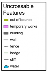
You must not cross: thick black lines (walls or fences), dark grey (buildings), olive-green (private gardens or flowerbeds), or solid areas of blue (canals, rivers or lakes). Other out of bounds areas are shown by solid purple (construction work) or closely-spaced vertical red-purple lines. In general, a thick black line represents a feature that is impassable, i.e. must not be crossed, whether or not it looks crossable.
The most common symbols for Uncrossable Features are shown on the right.
Map Symbols: The full set of symbols used on the maps for both days is shown here: (symbols)
SI electronic punching will be used. SI cards may be hired each day. There is no charge, but a cost of £30 will be charged if the card is lost.
Entries: via Fabian4, www.fabian4.co.uk - please read the additional entry information regarding Fabian4 entries.
Fees: (up to Fri. 6 June)
| Saturday | Sunday | Both days | |
|---|---|---|---|
| Seniors | £5 | £9 | £12 |
| Juniors | £3 | £5 | £6 |
Online entry will be possible up to Wed. 11 June at a surcharge of £2 per day for Seniors (no extra for Juniors).
EOD will also be possible at the same surcharged rate, provided maps are available.
Traders: Compass Point will have a stall at Assembly on Saturday. There will be no traders on Sunday.
Accommodation: There is plenty of accommodation available in Manchester. Contact:
Manchester Visitor Information Centre, Piccadilly Plaza, Portland Street, Manchester, M1 4BT. 0871 222 8223 www.visitmanchester.com/stay
The Castlefield Hotel (www.castlefield-hotel.co.uk), which is the event centre for the City of Manchester Race on the Sunday, is offering 10% discount to any competitors staying in the hotel for the event. This includes full use of the gym and swimming pool in the adjacent Y-Club, with which it is linked.
Other nearby accommodation includes the YHA (www.yha.org.uk/hostel/manchester)
Weekend Co-ordinator: Andrew Gregory (MDOC). Enquiries to
Day 1 - Northwest Sprint Championships
Details and results can be found on the Twin Peak Day 1 - Platt Fields and Fallowfield Campus event page.
Day 2 - City of Manchester Race
The Castlefield Arena will provide the assembly area and finish. Registration will be in the adjacent Castlefield Hotel, Liverpool Road, Manchester, M3 4JR.
Map
Scale 1:5000 with 5m contours, A4 size, double-sided (except for Course 7), ISSOM standard. Survey and cartography by Tom Fellbaum. Part of the map was used for the longer courses in the 2013 Salford urban event (map), but it has now been significantly extended to the East and North.
The control description symbol O is used for a large man-made pillar supporting a railway line.
There are a number of areas with multiple running levels. The main (top) level is fully mapped, including roads, walls and buildings. Routes along the bottom level are mapped using the purple crossing symbol and, if wide enough, the black dotted underpass symbol.
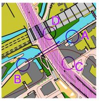 Where the crossing section goes under a wall or a building, these are mapped. Competitors are permitted to follow the crossing under these features.
In the first example (right) competitors must use the underpass when going between A and B, as the main road is out of bounds. Competitors can use the path by the side of the busy main road between C and D.
To go from A to D or from A to C, the competitor will need to turn off the towpath, go under the grey canopy and follow the path by the side of the main road to either D or C.
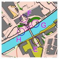 The crossing point symbol has been used to show allowed routes at a low level; the high level route across the top is also available, so please do not confuse this use of purple with the 'uncrossable boundary' thick purple line, which is not used at this event. In the second example (left), competitors can cross the bridge between E and F.
Competitors can go between F, G and H by going under the bridge following the routes mapped by the purple crossing sections.
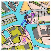 Competitors using the white curved canal bridge (shown in the map section right) must walk and not run. Otherwise the bridge may bounce. This is a requirement of the canal company. When the course has a leg with controls on both ends of the bridge, the time taken to cross the bridge (up to 1 minute) will be deducted from your final course time. Time will not be deducted if the competitor chooses to cross the bridge when the leg does not start and end at the bridge. Marshals will ensure that no one runs across the bridge.
Safety
Take great care when running along beside canals. The cobbled surfaces can be slippery if wet, and watch out for mooring ropes. Canals may only be crossed at the bridges marked on the map.
Watch out for pedestrians and cyclists and be courteous towards them. Take care near pavement cafés.
You are going to be running round the heart of the second largest urban area in Britain (source Wikipedia). Today's map is crossed by six A roads and a B road. They will be quiet on a Sunday morning, so with the exception of the timed-out crossing described below, senior competitors can cross where they wish. But please be careful. It isn't just you at risk; an inexperienced driver swerving to avoid you could have an accident. If the press picked up one such accident and gave it their usual lurid treatment, it could be the end of urban orienteering in the UK. If in doubt, wait.
Most competitors diagonally cross a road junction with traffic lights. Please approach it remembering that at such a junction you can cross either road first, depending on the state of the lights.
Tramlines are mapped as railways to emphasize them. Electric Metrolink trams are quiet and care is needed. Tramlines can be crossed where backed by the brown paved area screen, but not where backed by the olive forbidden access screen.
One road has a timed-out crossing at a pedestrian crossing. There are controls on both sides and you should only cross when the green pedestrian light shows. You have 2 minutes to cross, which is sufficient time to wait for the green light.
The junior courses are in an area with only very light traffic, but caution is still necessary.
Prize-giving
The Twin Peak prize-giving will take place as soon as possible after 2 pm. Prizes will be awarded to the winner in each BOF age class running on the appropriate course on both days.
Location

Nearest town: Manchester
- Grid Ref: SJ831978
- Postcode: M3 4JR
- Latitude: 53.47675
- Longitude: -2.25691
- Google Map
- Streetmap (OS 50k)
- Bing Map (OS 50k)
- OpenStreetMap
Directions / Parking
Castlefield Hotel, Liverpool Road, Manchester, M3 4JR.
Follow brown tourist signs to the Museum of Science and Industry (MoSI) on Liverpool Road, which is almost opposite the Castlefield Hotel. There will be O signs on Liverpool Road.
Driving: Please note that the western section of Liverpool Road and the adjacent section of Water Street are closed due to construction work, so both are blocked to through traffic.
Parking: The nearest covered car park is the NCP Great Northern, which costs £9.60 for 4 hours. From here, cross Deansgate to Liverpool Road. The NCP at Hulme Street is only £3 for 4 hours, and the nearby Medlock Street Q Park, operated by UKCPS has unlimited parking for £3. Both of these are accessed off Cambridge Street just north of the Mancunian Way (A57M). For the Q-Park turn left onto Chester Street, right at the end and then park either on the left or straight on. From both these car parks walk N or NW towards the very tall Beetham Tower, turn left on Whitworth Street West, turn right on Deansgate and then follow O signs.
Cheap car parking (£3-£4 a day) close to the event can be found by turning off the A57 north onto the A6402 and then right onto Water Street. Ask the attendant for Liverpool Road.
Metrolink: (revised 12 June)
Late News: Some Metrolink Trams are not running on Sunday 15 June. For details see the Metrolink web site.
Free parking is available at some Metrolink stations, including East Didsbury, Bury, Ladywell and Rochdale Railway Station. However, all the western half of the Metrolink tram network is closed on Sunday 15th June. Replacement buses are in operation, and a map of the bus stops is given on the Metrolink website: www.metrolink.co.uk.
If you use this option you need to buy a ticket to Deansgate-Castlefield. The stop for the replacement busses is on Whitworth Street West, and the event will be signed from this stop (north on Deansgate and then west on Liverpool Road).
Bus: Free Metroshuttle 2 bus from Oxford Road or Victoria Station to Liverpool Road or Deansgate/Great Bridgewater Street. Every 10 minutes from 10 am onwards.
Registration & Start Times
Registration, collection of race numbers for those who did not obtain their number on the Saturday, and other facilities including toilets, will be in the Castlefield Hotel. A room for changing and leaving kit will be available.
Assembly: The Castlefield Arena is a semi-sheltered stepped area and will make an excellent viewing point for the Start and Finish, which are both adjacent.
Registration: 10:00 - 12:00 Start times: 10:30 - 12:30
Start: The Start is adjacent to the Arena. It will be a Punching Start with a 4-minute call-up.
Finish: The Finish is in the Castlefield Arena. Download is in the Castlefield Hotel.
Courses close at 2:00pm, and controls will be removed from this time. If you think that you may still be out after 2:00pm, please ask to change your start to an earlier time.
Course Information
| Course | Men's classes | Women's classes | Length (km) | No. of controls |
|---|---|---|---|---|
| 1 | Men Open | 8.7 | 29 | |
| 2 | Vet Men (M40+) | Women Open | 7.5 | 23 |
| 3 | Super Vet Men (M55+) | Vet Women (W40+) | 6.1 | 27 |
| 4 | Ultra Vet Men (M65+) | Super Vet Women (W55+) | 4.8 | 23 |
| 5 | Ultra Vet Women (W65+) | 4.0 | 20 | |
| 6 | Junior Men (M16-) | Junior Women (W16-) | 3.4 | 19 |
| 7 | Young Junior Men (M12-) | Young Junior Women (W12-) | 2.0 | 15 |
The climb is negligible on all courses, with the only noticeable climb being steps, ramps between levels and towpath bridges. The lengths are straight-line distances, and the actual distance covered is likely to be about 30% more than that shown.
Junior courses will be within the Castlefield area, where there is very little traffic. Juniors under 16 years old on the day of the competition may not run on any of the longer courses unless accompanied by an adult. This is a requirement of the BOF insurance.
Explanation of colour courses
- White are very easy with all controls on paths. They are mainly used by 6-10 year olds and family groups.
- Yellow use simple linear features like paths, walls and streams. They are mainly used by under 12’s and family groups.
- Orange progress to basic use of the compass and route choice. They are ideal for novice adults or experienced youngsters.
- Light Green are ideal for improvers as the navigational difficulty begins to increase and uses simple contours and point features.
- Green are used mostly by experienced under 18’s and adults wanting a short but challenging course with a very hard navigational difficulty.
- Blue are a longer, more physically demanding course in comparison to the green. The distances are more varied between controls and the course attracts experienced orienteers.
- Brown & Black are very physically demanding and have a very hard navigational difficulty. They are for experienced orienteers only.
- Score means visiting as many controls as possible in any order in a specific time, like 45mins.
Terrain Description
Castlefield is an intricate area of canals, bridges, overhead railways, bars, restaurants and apartment blocks. It also includes a partially reconstructed Roman Fort. The extended urban area includes medieval, Victorian and modern buildings, and there are a variety of alleyways and open or semi-open spaces.
Facilities
Cafés and Restaurants: Options in the area include the Museum of Science and Industry which has both a café and a restaurant. Also, by the canals (near the white curved bridge):
- The Wharf: large canalside pub with outdoor terrace
- Dukes 92: a large bar and restaurant beside lock 92 on the Rochdale Canal, with extensive outdoor seating area
- Albert's Shed: an upmarket restaurant next to Dukes 92.
- Barca Bar and Restaurant, by lock 101 on the Bridgewater Canal
Other activities: The Museum of Science and Industry (free, but donation requested) contains the world's oldest passenger railway station, with replica historic locomotives operating. The museum also has an excellent new exhibition on the Large Hadron Collider (admission fee). (museum)
Contacts / Officials
Planner: Steve Lang (MDOC)
Organiser: Margaret Gregory (MDOC)
Assistant Organiser: Chris Kirkham (MDOC)
Controller: Peter Gorvett (SYO)
Safety and Risk
A comprehensive risk assessment will have been carried out by the organiser, but participants take part at their own risk and are responsible for their own safety during the event.
Privacy: when entering our events your name may appear in the results section of this website or in newspaper reports.
Read our privacy policy to see how we look after your personal data.